


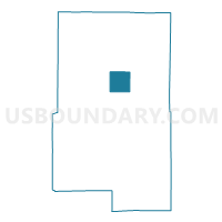
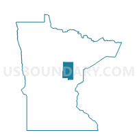
Workman Twp. Voting District, Aitkin County, Minnesota
About
Outline

Summary
| Unique Area Identifier | 600898 |
| Name | Workman Twp. Voting District |
| County | Aitkin County |
| State | Minnesota |
| Area (square miles) | 35.65 |
| Land Area (square miles) | 32.91 |
| Water Area (square miles) | 2.74 |
| % of Land Area | 92.32 |
| % of Water Area | 7.68 |
| Latitude of the Internal Point | 46.73157110 |
| Longtitude of the Internal Point | -93.36837210 |
Maps

Graphs
Select a template below for downloading or customizing gragh for Workman Twp. Voting District, Aitkin County, Minnesota


Neighbors
Neighoring Voting District (by Name) Neighboring Voting District on the Map
- Fleming Twp. Voting District, Aitkin County, MN
- Jevne Twp. Voting District, Aitkin County, MN
- Libby Twp. E Voting District, Aitkin County, MN
- Libby Twp. W Voting District, Aitkin County, MN
- Logan Twp. Voting District, Aitkin County, MN
- McGregor Twp. Voting District, Aitkin County, MN
- NW Aitkin Unorg. P-1 Voting District, Aitkin County, MN
- Shamrock Twp. Voting District, Aitkin County, MN
- Turner Twp. Voting District, Aitkin County, MN
Top 10 Neighboring County Subdivision (by Population) Neighboring County Subdivision on the Map
- Shamrock township, Aitkin County, MN (1,272)
- Northwest Aitkin UT, Aitkin County, MN (342)
- Jevne township, Aitkin County, MN (322)
- Fleming township, Aitkin County, MN (312)
- Turner township, Aitkin County, MN (208)
- Workman township, Aitkin County, MN (207)
- Logan township, Aitkin County, MN (184)
- McGregor township, Aitkin County, MN (105)
- Libby township, Aitkin County, MN (45)